Okay, crew, I have had like ZERO time to learn AutoIT and I have a problem that I need to solve.
Besides Wardriving, I also Geocache http://www.geocaching.com and I usually use a handheld GPS unit to point my way to the caches. Hoiwever, my GPSr has evaporated. I have been using a bodged together collection of freeware ( including Vistumbler) and google earth to ocontinue caching, but this setup limits me to urban areas where the GE aerial imagery has excellent resolution.
The challenge is to create an AutoIT application that allowes me to enter a set of corrdinates, compare them to my location, give me a range, distance and bearing along with a directional arrow pointing the way.
I figgure that since Vistumbler's GPS subroutines work so well and it already has a 'gps compass', it shouldn't be TOO difficult.
--Mystic
Project Mysticache
-
mysticvirgo67
- Mad Poster / Moderator / Promoter

- Posts: 424
- Joined: Sun Jun 28, 2009 4:52 pm
Project Mysticache
"People don't need restore. They just need recovery...and the occasional hard boot"
"The maximum acceleration of a PC is limited only by the amount of explosives used"
"The maximum acceleration of a PC is limited only by the amount of explosives used"
-
ACalcutt

- Vistumbler / TechIdiots Admin

- Posts: 1302
- Joined: Sun Oct 21, 2007 6:50 pm
- Location: Rutland, MA
- Contact:
Re: I have a challenge
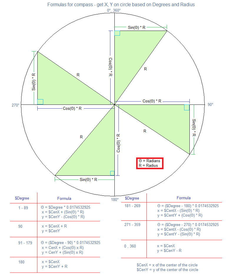
Mystic, this is basically a concept program to figure out the calculations I would need. I think i finally have it calculating right
Latitude an Logitudes need to be entered in decimal (not DMM or DMS)
Distance is in meters
Bearing is in degrees
Right now this can do two things
-Take Current GPS and Destination GPS and calculates Bearing and Distance
or
-Take current GPS, Bearing, and Distance and Calcutate the destination latitude and longitude
Then its basically a matter of automatically getting the current gps position automatically and showing the direction on the compass (http://plone.vistumbler.net/images/othe ... ormula.png)
- Attachments
-
- GpsCalc.zip
- (285.88 KiB) Downloaded 7309 times
-
mysticvirgo67
- Mad Poster / Moderator / Promoter
- Posts: 424
- Joined: Sun Jun 28, 2009 4:52 pm
Re: I have a challenge
ooh ooh ohh! i'll try it!
"People don't need restore. They just need recovery...and the occasional hard boot"
"The maximum acceleration of a PC is limited only by the amount of explosives used"
"The maximum acceleration of a PC is limited only by the amount of explosives used"
-
ACalcutt
- Vistumbler / TechIdiots Admin
- Posts: 1302
- Joined: Sun Oct 21, 2007 6:50 pm
- Location: Rutland, MA
- Contact:
Re: I have a challenge
Obligatory XCKD: http://xkcd.com/407/
I just noticed...the GpsCalc program I posted earlier was made in the future
I just noticed...the GpsCalc program I posted earlier was made in the future
-
mysticvirgo67
- Mad Poster / Moderator / Promoter
- Posts: 424
- Joined: Sun Jun 28, 2009 4:52 pm
Re: I have a challenge
Yeah that looks good Nice and simple. MAth looks right, too. I actually cannot STAND trig. Sines and cosines confuse me a bit. Umm.. yeah if it calcs on the fly thats great, the reciprical(grr no spellcheck!) course feature ( from waypoint back to origin) is a nice touch. maybe later a skinnable compass. I may get creative on the images for that one.
I think you can borrow the GPS subroutine from 'Stumbler.
BTW Upgraded my 'stumbler Nice to see the ranging feature. Helps me with triangulation a great deal!
Ran a scan today and had forgot that I had the Vagi hooked up instead of the omni. This was actually a fortuitous oversight! I remebered that, for some 'default' reason, that I had my Vagi pointed 45 deg to the right. So I figure I have a range and a bearing, then I can triangulate that way! I tried on a couple of detection points and it seems to work fine! At least gives me a much better idea where the AP's are!
"People don't need restore. They just need recovery...and the occasional hard boot"
"The maximum acceleration of a PC is limited only by the amount of explosives used"
"The maximum acceleration of a PC is limited only by the amount of explosives used"
-
mysticvirgo67
- Mad Poster / Moderator / Promoter
- Posts: 424
- Joined: Sun Jun 28, 2009 4:52 pm
Re: I have a challenge
Yeah I think I will play with my ap's now...
"People don't need restore. They just need recovery...and the occasional hard boot"
"The maximum acceleration of a PC is limited only by the amount of explosives used"
"The maximum acceleration of a PC is limited only by the amount of explosives used"


Re: I have a challenge
mystic, you do know Firefox has a spell check built in right?
it may not fix grammar but spelling it does lol
it may not fix grammar but spelling it does lol
The best acceleration you can get on a Mac is 9.8ms^2
-
mysticvirgo67
- Mad Poster / Moderator / Promoter
- Posts: 424
- Joined: Sun Jun 28, 2009 4:52 pm
Re: I have a challenge
Nah I like my mispellings and typos... shows character.... 
"People don't need restore. They just need recovery...and the occasional hard boot"
"The maximum acceleration of a PC is limited only by the amount of explosives used"
"The maximum acceleration of a PC is limited only by the amount of explosives used"
-
ACalcutt
- Vistumbler / TechIdiots Admin
- Posts: 1302
- Joined: Sun Oct 21, 2007 6:50 pm
- Location: Rutland, MA
- Contact:
Re: I have a challenge
Getting a little further along. Bearing and distance are now calculated on the fly. The GUI actually saves settings now. I added in the basic compass code from vistumbler. I don't know if the GPS part works yet (haven't gotten to test it since i forgot to get my gps from phil)
- mysticache.png (43.23 KiB) Viewed 2666629 times
- Attachments
-
- Mysticache.zip
- (373.43 KiB) Downloaded 7523 times
-
ACalcutt
- Vistumbler / TechIdiots Admin
- Posts: 1302
- Joined: Sun Oct 21, 2007 6:50 pm
- Location: Rutland, MA
- Contact:
Re: I have a challenge
What I am thinking about doing is adding a line on the compass to show what your actual bearing is(pulled from the gps).
I have the "Track Angle" from the GPRMC GPS string that i use for the vistumbler GPS Compass
Maybe make it so the actual bearing is the back line, and the destination bearing is a red line
I have the "Track Angle" from the GPRMC GPS string that i use for the vistumbler GPS Compass
Maybe make it so the actual bearing is the back line, and the destination bearing is a red line
-
ACalcutt
- Vistumbler / TechIdiots Admin
- Posts: 1302
- Joined: Sun Oct 21, 2007 6:50 pm
- Location: Rutland, MA
- Contact:
Re: I have a challenge
Ok, Got the GPS part working
- Attachments
-
- Mysticache.zip
- (374.08 KiB) Downloaded 7286 times
-
ACalcutt
- Vistumbler / TechIdiots Admin
- Posts: 1302
- Joined: Sun Oct 21, 2007 6:50 pm
- Location: Rutland, MA
- Contact:
Re: I have a challenge
Added GPS details
Added code to remember window positions
Added second line to the compass when using current gps to indicate the direction you are actually traveling (black line)
Changed Designation GPS Compass line color to red
Added code to remember window positions
Added second line to the compass when using current gps to indicate the direction you are actually traveling (black line)
Changed Designation GPS Compass line color to red
- Attachments
-
- Mysticache.zip
- (378.63 KiB) Downloaded 7344 times
-
mysticvirgo67
- Mad Poster / Moderator / Promoter
- Posts: 424
- Joined: Sun Jun 28, 2009 4:52 pm
Re: I have a challenge
That looks GREAT! You are the MAN, Andy! Awww.. and you named it after ME! I knew I liked you for some reason! 
"People don't need restore. They just need recovery...and the occasional hard boot"
"The maximum acceleration of a PC is limited only by the amount of explosives used"
"The maximum acceleration of a PC is limited only by the amount of explosives used"
-
mysticvirgo67
- Mad Poster / Moderator / Promoter
- Posts: 424
- Joined: Sun Jun 28, 2009 4:52 pm
Re: I have a challenge
Okay, I think it would be nice to show current GPS position under Start position.
Just did a test run, doesn't look like the subroutine for Current GPS position is working properly. With start coords entered, looks fine. Also GPS details...has it been fleshed out yet? showing empty data fields. My GPS Diffuser app is showing GPS functiononing properly
Just did a test run, doesn't look like the subroutine for Current GPS position is working properly. With start coords entered, looks fine. Also GPS details...has it been fleshed out yet? showing empty data fields. My GPS Diffuser app is showing GPS functiononing properly
"People don't need restore. They just need recovery...and the occasional hard boot"
"The maximum acceleration of a PC is limited only by the amount of explosives used"
"The maximum acceleration of a PC is limited only by the amount of explosives used"
-
mysticvirgo67
- Mad Poster / Moderator / Promoter
- Posts: 424
- Joined: Sun Jun 28, 2009 4:52 pm
Re: I have a challenge
BTW- Wifey said "Aaaawwwww!" When she saw the project name!
I like beta testing
I like beta testing
"People don't need restore. They just need recovery...and the occasional hard boot"
"The maximum acceleration of a PC is limited only by the amount of explosives used"
"The maximum acceleration of a PC is limited only by the amount of explosives used"
-
mysticvirgo67
- Mad Poster / Moderator / Promoter
- Posts: 424
- Joined: Sun Jun 28, 2009 4:52 pm
Re: I have a challenge
Lemme try one of the earlier versions you posted...that may be the better one...
"People don't need restore. They just need recovery...and the occasional hard boot"
"The maximum acceleration of a PC is limited only by the amount of explosives used"
"The maximum acceleration of a PC is limited only by the amount of explosives used"
-
ACalcutt
- Vistumbler / TechIdiots Admin
- Posts: 1302
- Joined: Sun Oct 21, 2007 6:50 pm
- Location: Rutland, MA
- Contact:
Re: I have a challenge
The "Current Position" and Gps Details both worked for me....maybe I'll have to write a program to capture your gps results so i can see whats up.
you remembered to click "Use GPS" right
I thought you would like the name
you remembered to click "Use GPS" right
I thought you would like the name
-
mysticvirgo67
- Mad Poster / Moderator / Promoter
- Posts: 424
- Joined: Sun Jun 28, 2009 4:52 pm
Re: I have a challenge
hmmm... dunno what it could be .. yeah run a gps cap app... I may have one, lemme dig about...
"People don't need restore. They just need recovery...and the occasional hard boot"
"The maximum acceleration of a PC is limited only by the amount of explosives used"
"The maximum acceleration of a PC is limited only by the amount of explosives used"
-
mysticvirgo67
- Mad Poster / Moderator / Promoter
- Posts: 424
- Joined: Sun Jun 28, 2009 4:52 pm
Thought I would drop a screencap
showing what I am not getting
Seems that MC is not geting any nema data. Is it possible that MC is not reading my GPS on com 10??? If I knew how to force my Laptop to take coms under 8 I would.
- mysticache screenshotsmaller.jpg (30.28 KiB) Viewed 2666594 times
"People don't need restore. They just need recovery...and the occasional hard boot"
"The maximum acceleration of a PC is limited only by the amount of explosives used"
"The maximum acceleration of a PC is limited only by the amount of explosives used"
-
ACalcutt
- Vistumbler / TechIdiots Admin
- Posts: 1302
- Joined: Sun Oct 21, 2007 6:50 pm
- Location: Rutland, MA
- Contact:
Re: I have a challenge
In that picture you haven't clicked the "Use GPS" button. it should say 'Stop GPS" if it is running.
Re: I have a challenge
hmm it usually helps to turn something on if you want to use it lol
damn Andrew I was just looking at the drive you did last night to Manchester, in the Daemon Generated KML, did you get lost on the way back ?! lol
damn Andrew I was just looking at the drive you did last night to Manchester, in the Daemon Generated KML, did you get lost on the way back ?! lol
The best acceleration you can get on a Mac is 9.8ms^2
-
ACalcutt
- Vistumbler / TechIdiots Admin
- Posts: 1302
- Joined: Sun Oct 21, 2007 6:50 pm
- Location: Rutland, MA
- Contact:
Re: I have a challenge
"Is it possible that MC is not reading my GPS on com 10"
you know...when I was testing this I had trouble using ports above 10. I was trying to make virtual com port with xport and it wouldn't connect....i finally found if i used com 5-7 it worked fine. so it is possible there is an issue.
Do you use port 10 in vistumbler? do you use kernel32 as the GPS interface in vistumbler?
-
mysticvirgo67
- Mad Poster / Moderator / Promoter
- Posts: 424
- Joined: Sun Jun 28, 2009 4:52 pm
Re: I have a challenge
yeas I use port ten wit VSt. apparantly 1-9 are reserved for some reason only HP knows. am using the NetComm interface. Nice and stable
"People don't need restore. They just need recovery...and the occasional hard boot"
"The maximum acceleration of a PC is limited only by the amount of explosives used"
"The maximum acceleration of a PC is limited only by the amount of explosives used"
-
mysticvirgo67
- Mad Poster / Moderator / Promoter
- Posts: 424
- Joined: Sun Jun 28, 2009 4:52 pm
Re: I have a challenge
pferland wrote:hmm it usually helps to turn something on if you want to use it
damn Andrew I was just looking at the drive you did last night to Manchester, in the Daemon Generated KML, did you get lost on the way back ?! lol
Nah he decided to Geocache!
"People don't need restore. They just need recovery...and the occasional hard boot"
"The maximum acceleration of a PC is limited only by the amount of explosives used"
"The maximum acceleration of a PC is limited only by the amount of explosives used"
-
mysticvirgo67
- Mad Poster / Moderator / Promoter
- Posts: 424
- Joined: Sun Jun 28, 2009 4:52 pm
Re: I have a challenge
Just tried all the available USB ports None worked but gor an access violation type error on purt 3 I think that may be what my USB mouse is on.
"People don't need restore. They just need recovery...and the occasional hard boot"
"The maximum acceleration of a PC is limited only by the amount of explosives used"
"The maximum acceleration of a PC is limited only by the amount of explosives used"
-
mysticvirgo67
- Mad Poster / Moderator / Promoter
- Posts: 424
- Joined: Sun Jun 28, 2009 4:52 pm
Re: I have a challenge
??purt?? LOL
"People don't need restore. They just need recovery...and the occasional hard boot"
"The maximum acceleration of a PC is limited only by the amount of explosives used"
"The maximum acceleration of a PC is limited only by the amount of explosives used"
-
ACalcutt
- Vistumbler / TechIdiots Admin
- Posts: 1302
- Joined: Sun Oct 21, 2007 6:50 pm
- Location: Rutland, MA
- Contact:
Re: I have a challenge
Can you see if you can connect to port 10 in vistumbler when using Kernel32 instead of Netcomm
-
mysticvirgo67
- Mad Poster / Moderator / Promoter
- Posts: 424
- Joined: Sun Jun 28, 2009 4:52 pm
Re: I have a challenge
ummm Actually, no,I haven't. Might be the reason I cant use the lower com "purts"
"People don't need restore. They just need recovery...and the occasional hard boot"
"The maximum acceleration of a PC is limited only by the amount of explosives used"
"The maximum acceleration of a PC is limited only by the amount of explosives used"
-
ACalcutt
- Vistumbler / TechIdiots Admin
- Posts: 1302
- Joined: Sun Oct 21, 2007 6:50 pm
- Location: Rutland, MA
- Contact:
Re: I have a challenge
Here, lets try this
-Added CommMG, and Netcomm OCX interface GPS options (in addition to the Kernel32)
-Added current Latitude and Longitude to the "Current GPS Position" radio button text
-Added button to pull the current gps position into the self specified start latitude and longitude
-Added CommMG, and Netcomm OCX interface GPS options (in addition to the Kernel32)
-Added current Latitude and Longitude to the "Current GPS Position" radio button text
-Added button to pull the current gps position into the self specified start latitude and longitude
- mysticache0-8.png (77.71 KiB) Viewed 2666572 times
- Attachments
-
- Mysticache0-8.zip
- (554.61 KiB) Downloaded 7258 times
-
mysticvirgo67
- Mad Poster / Moderator / Promoter
- Posts: 424
- Joined: Sun Jun 28, 2009 4:52 pm
Re: I have a challenge
Tried the Kernal interface on Vistumbler with my GPSr and could not talk to my particular GPSr at all. Got a communications error. D-loading MC 0.8 and testing. Give me a day or so.
"People don't need restore. They just need recovery...and the occasional hard boot"
"The maximum acceleration of a PC is limited only by the amount of explosives used"
"The maximum acceleration of a PC is limited only by the amount of explosives used"
-
mysticvirgo67
- Mad Poster / Moderator / Promoter
- Posts: 424
- Joined: Sun Jun 28, 2009 4:52 pm
Re: I have a challenge
okay got the GPS and Mysticache to talk using Comm MG. 
I think this is to call it version 1.0.0
I think this is to call it version 1.0.0
"People don't need restore. They just need recovery...and the occasional hard boot"
"The maximum acceleration of a PC is limited only by the amount of explosives used"
"The maximum acceleration of a PC is limited only by the amount of explosives used"
-
mysticvirgo67
- Mad Poster / Moderator / Promoter
- Posts: 424
- Joined: Sun Jun 28, 2009 4:52 pm
Re: I have a challenge
Excellent progress! There are a few bits of polishing to be had, but so far Mysticache is excellent! You are soooooo goooooood!
There are a few polishing bits to be had:
the compass jumps about quite a bit. Yeah I know this is a trait of GPS in and of itself and since my handheld does the same thing, but this app is bouncing around way too much. Is there some sort of averaging calcs that can be done to damp this out? This app runs pretty fast right now, so I think there is processing room for it.
Geocachers are pretty diverse when it comes to what coord formats they like to use. The Coords posted on Geocaching .com are Decimal minutes, so that is what most cachers are used to using. So perhaps it is time for ability to select DD, DM and DMS. I prefer UTM myself, BUT I am not going to torture you with the conversion for that one. I think converting lat long to UTM requires tables or such. I think I will research that sometime.
A Save Waypoint button is necessary. Adapt the Export function from Vistumbler, perhaps? TXT, CSV,GPX and XML at minimum. Would be a good idea to work some sort of best out of # algorithim to toss out rogue fixes. Accuracy is a must when caching and especially so when placing a cache. There have been so many times when I have been out looking for a cache and find out that the posted coords were more than 30 ft from actual placement because the cacher that placed it had posted an errant fix.
I have found that averaging a fix doesn't work because one or two bad fixes can throw off the posted coords quite a bit.
Dropdown menus a-la Vistumbler would be nice for settings , options and such.
Again, I can work without most of these , but damping the compass is important
Okay. I will leave you be for a while. I need to fieldtest the new version
"People don't need restore. They just need recovery...and the occasional hard boot"
"The maximum acceleration of a PC is limited only by the amount of explosives used"
"The maximum acceleration of a PC is limited only by the amount of explosives used"
-
ACalcutt
- Vistumbler / TechIdiots Admin
- Posts: 1302
- Joined: Sun Oct 21, 2007 6:50 pm
- Location: Rutland, MA
- Contact:
Re: I have a challenge
The issue with the compass jumping around should only happen when you are staying still. What "Track Angle" represents is the direction you are traveling. So, when you are staying still this value isn't accurate. I guess it could be averaged out, but if its jumping around the average is likely not to be accurate either.
Selecting of GPS format is something I plan on adding, along with measure of distance selection (miles, feet, yards, kilometers, etc).
What do you mean by saving a waypoint. do you mean like making a kml with current or destination coordinates?. What exactly would you expect to see in the export file. (Like are you looking to save history of the route you took?)
-
ACalcutt
- Vistumbler / TechIdiots Admin
- Posts: 1302
- Joined: Sun Oct 21, 2007 6:50 pm
- Location: Rutland, MA
- Contact:
Re: I have a challenge
I just looked at the lat/lon to to UTM conversion(http://www.uwgb.edu/dutchs/UsefulData/U ... tm)....now my head hurts
-
ACalcutt
- Vistumbler / TechIdiots Admin
- Posts: 1302
- Joined: Sun Oct 21, 2007 6:50 pm
- Location: Rutland, MA
- Contact:
Re: I have a challenge
Something else i have been thinking about is a better way to represent distance from the compass
What i am thinking is circles to indicate distance like this
Basically it would show only one of the colored circles at a time. (not all like shown in the pic)
Distance would change color and position
Outer red - less than 400m away
orange - less than 200m away
yellow - less than 100m away
green-yellow - less than 50m away
dark green - less than 25m Away
(maybe make this distances settable)
What i am thinking is circles to indicate distance like this
- range_compass.png (16.83 KiB) Viewed 2666554 times
Basically it would show only one of the colored circles at a time. (not all like shown in the pic)
Distance would change color and position
Outer red - less than 400m away
orange - less than 200m away
yellow - less than 100m away
green-yellow - less than 50m away
dark green - less than 25m Away
(maybe make this distances settable)
-
mysticvirgo67
- Mad Poster / Moderator / Promoter
- Posts: 424
- Joined: Sun Jun 28, 2009 4:52 pm
Re: I have a challenge
I was just thinking about that myself... and maybe audio output for range, increaceing frequency with decreasing distance, starting at maybe 50 meters.
On the ranging circle, invert the color scheme. Blue>100m Down to a flashing red ( can you do a flashing?) at <2m Make the ranges adjustable if ya like. Adjustability and customization is always good. I was also thinking a ranging tone like a classic sonar ping would be cool, too... the ping rate being inverse of range.
I ran a field trial today. Went after a nearby cache that I hadn't bagged yet. Noticed a couple minor usability quirks. I found myself forgetting which compass indicator was what. I think a little text note on bottom of compas window would be helpful along with tickmarks every 15 degrees around the compass.
Watching the compass lines merge was cool as hell!
I told ya the UTM conversion would cause your head to spin! I've been sorta forced to use it because my Handheld is ancient and is only accurate to 100/th of a minute. This is no good in the least for tracking down 35mm filmcans in the woods. Let alone a 5mmx5mm 'nanocache' in a stone wall. UTM is intrensically precise to within a meter.
Setable Coordinates system is a great idea, but default to decimal minutes. This is default format for posting caches at geocaching.com.
I think that if you strip the AP features from vistumbler, then this will be good for saving waypoints and routes. Add a dialog box with a field to name the waypoint/route. For now I think we can save as a Vistumbler file. I think this feature should be a separate window.
I was also thinking that the compass might look nicer if was drawn in the main interface. Cleaner design. With option to detach, of course.
I will post more in a short while. Away from house ATM and I need to close up to leave.
"People don't need restore. They just need recovery...and the occasional hard boot"
"The maximum acceleration of a PC is limited only by the amount of explosives used"
"The maximum acceleration of a PC is limited only by the amount of explosives used"
-
ACalcutt
- Vistumbler / TechIdiots Admin
- Posts: 1302
- Joined: Sun Oct 21, 2007 6:50 pm
- Location: Rutland, MA
- Contact:
Re: I have a challenge
Started messing with the circle idea. went with my version for now (and no....flashing lines would be hard the way i am doing it)
right now i am using set distances
Dark Green: <= 25
Yellow-Green: <= 50
Yellow: <= 100
Orange: <= 200
Light Red: <= 400
Dark Red: <= 800
One thing at a time mystic
right now i am using set distances
Dark Green: <= 25
Yellow-Green: <= 50
Yellow: <= 100
Orange: <= 200
Light Red: <= 400
Dark Red: <= 800
One thing at a time mystic
- Attachments
-
- Mysticache0-9.zip
- (555.24 KiB) Downloaded 7210 times
-
mysticvirgo67
- Mad Poster / Moderator / Promoter
- Posts: 424
- Joined: Sun Jun 28, 2009 4:52 pm
Re: I have a challenge
I know one at a time.... Lets just say I am a buffet of ideas, pick and choose and don't forget to use a fresh plate
"People don't need restore. They just need recovery...and the occasional hard boot"
"The maximum acceleration of a PC is limited only by the amount of explosives used"
"The maximum acceleration of a PC is limited only by the amount of explosives used"
-
mysticvirgo67
- Mad Poster / Moderator / Promoter
- Posts: 424
- Joined: Sun Jun 28, 2009 4:52 pm
Re: I have a challenge
That looks sweet! I will toy with it more tomorrow. Though I really do think that the range values are too large. This sort of tool really ought to be more precise. Most cachers have no problem getting to within 25- 30 meters with google earth alone.
May I suggest
Dark Green <= 2 m
Light Green <= 5 m
Yellow <= 10 m
Orange <= 20m
Light red <= 30m
Dark red <= 40m
Flashing lines was just a 'that is cool' sort of thing.. if it is hard, don't sweat it.
If toss ya an idea that is just a pain in the ass with autoit, let me know
This is a fun project so far and you seem to be having fun too. I don't want to lose that by turning into a 'boss' type.
I think you may have seen that when I get to brainstorming, I tends to develop into an idea hurricane.
You should see me when I am designing landscapes.
"People don't need restore. They just need recovery...and the occasional hard boot"
"The maximum acceleration of a PC is limited only by the amount of explosives used"
"The maximum acceleration of a PC is limited only by the amount of explosives used"
-
mysticvirgo67
- Mad Poster / Moderator / Promoter
- Posts: 424
- Joined: Sun Jun 28, 2009 4:52 pm
Re: I have a challenge
Yeah one step at a time... umm what are you planning to approach after the "graphic Ranging Module"? MAn that sounded impresive, eh?
"People don't need restore. They just need recovery...and the occasional hard boot"
"The maximum acceleration of a PC is limited only by the amount of explosives used"
"The maximum acceleration of a PC is limited only by the amount of explosives used"
-
mysticvirgo67
- Mad Poster / Moderator / Promoter
- Posts: 424
- Joined: Sun Jun 28, 2009 4:52 pm
Re: I have a challenge
Wait Lets keep the ranging values easy, like you said, but I think I would reduce them by a factor of 10 with dark red <= 2 meters. That is close to a seven foot radius.. that is plenty close for searching. If a veteran geocacher can't find a cache in that range, then it was either muggled (slang for swiped) or he entered the wrong coords to begin with.
"People don't need restore. They just need recovery...and the occasional hard boot"
"The maximum acceleration of a PC is limited only by the amount of explosives used"
"The maximum acceleration of a PC is limited only by the amount of explosives used"
-
mysticvirgo67
- Mad Poster / Moderator / Promoter
- Posts: 424
- Joined: Sun Jun 28, 2009 4:52 pm
Re: I have a challenge
Whoops caught this in version 0.9 this morning(0730). The text on the destination button is misspelled.
"People don't need restore. They just need recovery...and the occasional hard boot"
"The maximum acceleration of a PC is limited only by the amount of explosives used"
"The maximum acceleration of a PC is limited only by the amount of explosives used"
Re: I have a challenge
Just use Loki from www.skyhookwireles.com
-
ACalcutt
- Vistumbler / TechIdiots Admin
- Posts: 1302
- Joined: Sun Oct 21, 2007 6:50 pm
- Location: Rutland, MA
- Contact:
Re: I have a challenge
Loki is totally different than Mysticache
Loki is more like our Vistumbler WiFiDB GPS locate (which uses the APs around you to determine your location)
Loki is more like our Vistumbler WiFiDB GPS locate (which uses the APs around you to determine your location)
-
ACalcutt
- Vistumbler / TechIdiots Admin
- Posts: 1302
- Joined: Sun Oct 21, 2007 6:50 pm
- Location: Rutland, MA
- Contact:
Re: I have a challenge
I think i am going to label 0.9 as v1.0 as long as everything seems to be working. Then i am going to start working on v2.0
I have started stripping down the vistumbler GUI as a base. This is what I am thinking so far for the GUI (this is not functional yet...still just messing with the gui at this point)
I have started stripping down the vistumbler GUI as a base. This is what I am thinking so far for the GUI (this is not functional yet...still just messing with the gui at this point)
- Mysticache2.png (56.46 KiB) Viewed 2666532 times
Re: I have a challenge
it looks like a vistumbler jr. lol
The best acceleration you can get on a Mac is 9.8ms^2
-
mysticvirgo67
- Mad Poster / Moderator / Promoter
- Posts: 424
- Joined: Sun Jun 28, 2009 4:52 pm
Re: I have a challenge
Tee hee, Visicache??? I was thinkng more along the line of the Vistumbler GUI being secondary to the current primary Mysticache GUI.. right? I have always had a fondness for apps with 'familial' semblances. <pinches new app's little chubby cheeks.> Ain't it CUTE!!!
"People don't need restore. They just need recovery...and the occasional hard boot"
"The maximum acceleration of a PC is limited only by the amount of explosives used"
"The maximum acceleration of a PC is limited only by the amount of explosives used"
-
mysticvirgo67
- Mad Poster / Moderator / Promoter
- Posts: 424
- Joined: Sun Jun 28, 2009 4:52 pm
Re: I have a challenge
Romeomoon, Loki only works if thier server can locate a nearby registed access point. Quite useless when in rural locations trying to find a tupperware container full of trinkets in the woods.
Thank you much for posting and welcome to Vistumbler forums!
Thank you much for posting and welcome to Vistumbler forums!
"People don't need restore. They just need recovery...and the occasional hard boot"
"The maximum acceleration of a PC is limited only by the amount of explosives used"
"The maximum acceleration of a PC is limited only by the amount of explosives used"
-
mysticvirgo67
- Mad Poster / Moderator / Promoter
- Posts: 424
- Joined: Sun Jun 28, 2009 4:52 pm
Re: I have a challenge
Andrew, I was thinking of the ranging circles again... can a button be added to compass to switch between a long range setting ( your current default) and a close range setting (perhaps 1/10 current ranging values)?
If it is possible ( IE not HARD) with AutoIT, I think this may be a nice compromise...
Wife and I bagged four more geocaches yesterday.. Found no software faults. Tried to get wife to use Mysticache while we were in the car, but she isn't comfortable with it just yet.
I was also wondering how difficult it would be in Auto IT to animate the Compass to allow the compass points (NSEW) to rotate about the compass instead of using the current heading pointer? There are a large group of people who cant visualize where north is LOL.. easier to orient to actual direction of travel.
No pressure, was just thinking of version 3.0
I am really wishing I had the time to sit down and work on learning Auto IT more. So hard to do with kids and a wife with medical issues....
"People don't need restore. They just need recovery...and the occasional hard boot"
"The maximum acceleration of a PC is limited only by the amount of explosives used"
"The maximum acceleration of a PC is limited only by the amount of explosives used"